Groundwater Monitoring: Some Deficiencies and Opportunities
John A. Cherry
Waterloo Centre For Groundwater Research
University of Waterloo
Waterloo, Ontario N2L3Gl
INTRODUCTION
In the past decade monitoring for groundwater quality has evolved from a minor endeavor with few techniques and low cost per site. It is now a large industry in North America, involving many new and old techniques, tens of thousands of sites and, in many cases, millions of dollars per site. The capability of the monitoring industry to acquire accurate and reliable data from a well has improved immensely. However, severe deficiencies in overall monitoring capability remain. This paper addresses some of these deficiencies and their causes and implications.
A decade ago, it was common if not prevalent for groundwater monitoring at waste disposal or industrial sites to be accomplished using a small number of conventional wells with long sand packs and screens. A long screened well offered large cost savings over the alternative of the day, which was a nest or cluster of wells at different depths at each location. Groundwater monitoring networks comprised largely of long screened wells were a two-dimensional attempt to monitor three-dimensional systems. Recent experience at numerous sites shows that pathways for contaminant migration are typically complex in three dimensions. Monitoring well networks have become much more three dimensional as recognition of the nature of hydrogeologic systems grows. The monitoring network of today is more sophisticated and expensive than in past decades but whether it is actually accomplishing proper site characterization and early warning detection, and providing adequate data for remedial design or remedial performance assessment is problematic. The designer of monitoring networks is caught in a conundrum: the need for a large number of wells to satisfy the demands of complex groundwater systems, with the reality of high coat per well often limiting wells in the network to an inadequate number relative to the complexity of the problem.
Mackay (1990) provided a vivid description of the problem facing the designer of groundwater monitoring networks:
"Envision an extremely complex maze in which are lost a variety of chemicals--some concentrated and localized, and some dilute and spread out. Imagine further that the chemicals are all moving at different rates and directions as a result of gravity and/or the flow of air and water through the maze. Then imagine that the internal walls of the maze are porous, like a hedge, and that the chemicals, air or water can move into and even through them at rates that vary throughout the maze. Lastly, imagine that you must find [] all of the chemicals but cannot enter the maze to do so."
In the first part of this paper I consider the implications for groundwater monitoring of some recent studies pertaining to contaminant behavior in groundwater. The overall emphasis is on organic chemicals. The discussion focuses on three facets of site hydrogeology; transverse dispersion in heterogeneous sandy aquifers, fractures in aquitards, and heavier-than-water immiscible industrial liquids. These are the main areas of my site-investigation experience in the past decade.
The term "conventional monitoring well" is used frequently in this paper. This refers to a single well in a single borehole. The well has a screen of moderate or short length at the bottom, a sand or gravel pack is placed around the screen and the entire portion of the borehole annulus above the sand pack is sealed to surface with an impervious material such as cement grout or bentonite slurry.
HYDRODYNAMIC DISPERSION
Dispersion has received much attention from the groundwater research community in the past three decades. Lehr(1988) argued that excessive attention has been paid to this topic and that it is no longer worthy of priority in research. Regardless of the issue of priority, research findings of the past decade on dispersion have immense implications for groundwater monitoring. The following consideration of the topic pertains to contaminant transport in porous media such as sand and gravel rather than fractured rock.
Plumes of dissolved-phase contamination generally travel more or less horizontally through sand or gravel aquifers because these aquifers, as broad geologic deposits, are typically close to horizontal. Therefore, it is convenient to consider dispersion in terms of the following three principle directions: longitudinal, transverse horizontal, and transverse vertical. Dispersion is the process that causes dilution and spreading of plumes, with spreading occurring in the three principle directions.
Three-dimensional natural-gradient tracer tests in sandy aquifers done during the 1980s, with detailed spatial monitoring over long time periods, showed that dispersion is a very weak process in the two transverse directions, horizontal and vertical (Sudicky et. al.1983; Freyberg et. al. 1986; Moltyaner and Killey, 1988; Garabedian et. al. 1991). These experiments provided new insight on dispersion. Recently, this insight was used in the design of monitoring networks for actual contaminant plumes in the three-dimensional detail necessary to determine whether the results of the tracer tests were applicable at the full plume scale. LeBlanc (1984), Robertson et. al.(1991), Robertson and Cherry (in press), and Luba (1991) showed, for several unconfined sandy aquifers of various depositional origins, that contaminant plumes from infiltrated sewage have weak transverse dispersion. Mackay and Cherry (1989) presented maps of several plumes at industrial sites also showing long thin shapes indicative of weak transverse horizontal dispersion. Cherry (1983) and MacFarlane et. al. (1983) presented concentration versus depth profiles indicating weak vertical dispersion in plumes at municipal landfills. These field studies based on detailed monitoring and many other field studies published in recent years indicate that weak transverse dispersion is common in sand and gravel aquifers. In some cases transverse dispersion is not much stronger than the effect of molecular diffusion alone.
Prior to the 1980s studies of dispersion dealt almost exclusively with longitudinal dispersion. Although longitudinal dispersion is of theoretical interest, it is of little practical importance in groundwater monitoring. Longitudinal dispersion influences the arrival time of contaminants at monitoring wells, however the main uncertainty in arrival time involves the hydraulic conductivity distribution and contaminant source condition rather than dispersion.
Prior to the mid 1980s the values of transverse dispersivity used in practical applications of mathematical models to sandy aquifers were generally orders of magnitude larger than the values obtained from the natural gradient tracer tests mentioned above. In most cases dispersivity was used as a smoothing factor in the model, covering the effects of several types of uncertainties including dispersion. This gave the impression that transverse dispersion was a much stronger process than recent tracer tests and detailed plume studies have established. For the designers of monitoring networks these findings on dispersion present a problem not evident a few years ago. The monitoring targets intended for delineation using a well network, such as zones of peak concentration within a complex plume or simply the location of a narrow plume in an aquifer, tend to grow (i.e. expand due to dispersion) only slightly as the plume travels down-gradient from the source. Many plumes are heterogeneous in concentration distribution at the source because of spatially and temporally variable inputs of contamination, and complex site geology. Because of weak dispersion the degree of concentration heterogeneity diminishes very little down gradient, requiring a more dense network of wells. In some plumes the difference between detecting or missing a concentration zone orders of magnitude above a regulatory limit is difference in positioning in depth of the critical well by a only meter or two.
At a landfill where the monitoring network is used for early warning of contamination, a likely prospect for contamination to enter groundwater would be a hole in the liner. The width of the contaminant entry-area to groundwater beneath the landfill would tend to be narrow. Due to weak transverse dispersion the spacing between monitoring wells down-gradient would need to be equally narrow to provide much probability that the network would eventually detect the leak. Consideration of spacing between monitoring wells then becomes almost entirely dependant on estimates of the width of the contaminant entry-area at the source. From this it follows that, at many waste disposal or industrial sites, the spacing of wells in both the vertical and horizontal directions, is too large to detect the main impacts of the type of leakages or spills most likely to cause groundwater contamination ( Figure 1 ). If transverse dispersion were to have as strong a spreading effect as was previously believed, this monitoring problem would be much less severe because plumes would spread out rapidly in the transverse directions as the plume front advances, thereby being at least detectable (but not necessarily mappable) by widely spaced wells.

DENSE NON-AQUEOUS PHASE LIQUIDS
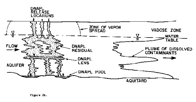
Dense non-aqueous phase liquids (DNAPLs) are now recognized as one of the most common and complex causes of groundwater contamination in industrial regions. A DNAPL site is one where DNAPL, as residual or free-liquid phase, exists below the water table. DNAPLs are a unique threat to groundwater quality because they commonly sink below the water table where they dissolve slowly. DNAPL dissolution causes long-term formation of plumes emanating from the zones of DNAPL. DNAPL may also exist above the water table but the mass below the water table is usually the cause of most or nearly all of the ground water impact (Figure 2). The important types of DNAPL are chlorinated solvents, creosote/coal tar, PCB oil and some pesticides. Schwille (1988) provided descriptions of the behavior of DNAPL in porous and fractured media. Huling and Weaver (1991) presented a summary of current knowledge about DNAPL behavior in groundwater. Mackay and Cherry (1989) considered the influence of DNAPL on concentrations from pumping wells.
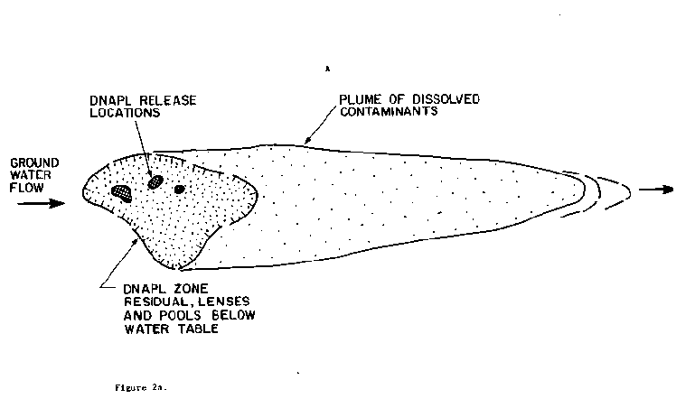
DNAPLs have gotten into aquifers from disposals to pits of industrial liquid wastes, and leakages from drums, distribution lines, sumps, underground tanks, liquid transfer connections, dry wells and highway and rail accidents. The input zones to the water table are often small and therefore the core of dissolved-phase plumes emanating from the DNAPL zones below the water table is typically small in cross sectional view. Some DNAPLs such as the chlorinated solvents( i.e. tetrachloroethylene, trichloroethylene, trichloroethane ) have a factor of ten thousand or more between their aqueous solubility and maximum concentration permitted in drinking water (MCLs). DNAPL mass tends to be distributed with exceptional spatial heterogeneity below the water table, thereby producing dissolved-phase plumes with extreme complexity. These complex distributions are often beyond the capability of even unusually expensive networks of conventional monitoring wells to provide the data necessary for reliable risk assessments, design of remedial systems or remediation performance evaluations.
The problems referred to above for DNAPL site monitoring pertain to the spatial and temporal resolution of concentration distributions. However, an even more difficult DNAPL monitoring problem is the installation of monitor wells in areas of DNAPL without causing lenses or pools of DNAPL to drain liquid DNAPL down the borehole or well to deeper levels in the aquifer. Many DNAPLs have a specific gravity between 1.2 and 1.6, low viscosity and low interfacial tension. This gives them strong propensity to move downward through small openings created by drilling or well installation. In hydogeologic settings where no major aquitard exists into which casing can be keyed at the bottom of a DNAPL pool, there is no proven technology for drilling through such DNAPL zones without draining liquid DNAPL deeper in the aquifer or otherwise inducing artificial complexities in the monitoring data.
The worst circumstances are generally found in fractured rock. Extreme precautions can be taken which may minimize these problems in some cases. However, without detailed prior knowledge of the locations of the lenses or pools of DNAPL the precautions can be futile. Such prior knowledge must derive from drilling, a Catch-22 situation. Considering the inadequacy of present drilling technology in this context it is often inadvisable to drill in areas of known or suspected DNAPL. Unconventional strategies for site investigation should be pursued. Specialized equipment suitable for this challenge is needed.
FRACTURED AQUITARDS
In the simplest conceptualization hydogeological systems are comprised of aquifers and aquitards. Aquifers are normally the focus of attention because they are the source of water supply and are the zones where large contaminant plumes develop. At waste disposal or industrial sites, however, aquitards are often as important as the aquifers. The problems of monitoring aquitards are much different than those of aquifers.
In sedimentary terrain aquitards typically are strata comprised of silt, clay, siltstone or shale in which nearly all groundwater flows through fractures (the term fracture is used here for all types of secondary openings such as joints, fissures and bedding planes). In many aquitards vertical fractures exist and in situations where the fractures extend from top to bottom, these fractures often provide pathways for contaminants to move through the aquitard into underlying aquifers. One of the reasons why groundwater contamination is now so common in industrial regions is the leakiness of aquitards due to fractures, primarily vertical fractures.
Using numerical simulations Sudicky and McLaren (in press) and Harrison et. al. (in submittal) showed major impacts of dissolved contaminants, such as chloride and trichloroethylene, on an underlying aquifer due to movement through small vertical fractures in an overlying clay aquitard. Vertical fractures as small as 10 or 25 microns were found to be important. To put these aperture sizes in context, twenty microns is approximately the diameter of a human hair and 100 microns is approximately the diameter of a single sheet of writing paper. Kueper and McWhorter (1991) show by theoretical analysis that DNAPL with common physical properties can easily move downward through vertical fractures having apertures of only 5 to 10 microns. Aquitards with moderately or widely spaced vertical fractures having apertures of a few tens of microns or less exhibit very low bulk vertical hydraulic conductivity, even less than 10 minus 7 or minus 8 cm/s. These studies indicate that aquitards that are nearly impermeable in a hydraulic context can be quite transmissive for contaminant migration, including both dissolved phase and immiscible phase contaminants.
In site investigations a frequent goal is to determine the propensity for contaminants to move through a particular aquitard so that proper pathway analyses for risk assessments can be made or for design of remedial action. It is necessary to know whether fractures offer migration pathways because some of the remedial options under consideration may cause mobilization of contaminants from an upper aquifer to a deeper aquifer. One of the most difficult site investigation tasks is the determination of the presence or absence of critical fractures in an aquitard. Present techniques are crude and often provide unreliable answers. This is not surprising considering that todays technology for groundwater monitoring was developed primarily for aquifers and not aquitards.
RECENT ADVANCES IN GROUNDWATER MONITORING
Groundwater monitoring has advanced considerably in the past decade, primarily as a result of the demand for monitoring created by SUPERFUND and RCRA. The improvements have come almost exclusively in areas of conventional monitoring; they allow conventional monitoring to be done better. For example, many conventional monitoring wells are now constructed from materials appropriate for detection of parts per trillion levels of organic compounds. Various new sampling pumps suitable for parts per billion or parts per trillion studies are now available for sampling these wells. New types of drilling equipment can be used to obtain better soil samples and set monitor wells with less formation disturbance. Sophisticated borehole geophysical techniques provide new insight to the details of site geology. Analytical laboratories are now capable of routine detection of many groundwater contaminants at orders of magnitude lower levels than was the case a decade ago.
The 198Os was the decade of development of stringent protocols for groundwater sampling and sample analysis. Gone are the days when field personnel could drop an old bailer down a well for sampling after casual purging and then splash the sample into whatever type of sample bottle that happened to be on hand. There is now much standardization in groundwater monitoring and, with this, much improvement in the quality of data provided by individual monitoring wells. With these improvements in well design, well materials, sampling pumps and field and laboratory screened hollow-stem auger are examples of recent technologies for obtaining head and chemical data at many depths in boreholes as drilling proceeds. The screened auger is used in permeable sand or gravel to depths generally not greater than 40 or 50 meters. The piezo-cone functions best in soft silty or clayey deposits in which the cone can be pushed under heavy load applied at surface. Because these techniques perform well only in a few types of overburden deposits and because of depth limitations, they can only be used in some regions. They offer possibilities for drilling in DNAPL zones because frequent sampling and analysis is done as the hole advances. This provides for drilling to cease when concentrations indicative of DNAPL are encountered. However, these methods, like other drilling methods, do not prevent DNAPL from draining deeper in the hole if the hole penetrates below a DNAPL zone. The piezo-cone and the screened auger have yet to be connected to field analysis equipment to produce laboratory-grade analyses on-site as drilling proceeds.
The technically advanced piezo-cone has sensors positioned near the tip of the drive-point penetrating the geologic material. The advantages of these tip sensors are many. There is a need for other drilling methods to have chemical and pressure sensors on or near the drill bit.
Use of Conventional Monitoring Wells For Contamination Scanning
Sampling of conventional wells using the standard protocol involves purging of several well-casing volumes before sampling. The purging is intended to produce samples of formation water free of artifacts related to reactions with well materials or gas transfer at the top of the water column. Normally, only one sampling is done after purging. The objective of this standard protocol is to produce a sample representative of the formation water in the immediate vicinity of the well screen. This type of sample is referred to here as a point sample. If the monitoring is being done to locate plumes that could be narrow and therefore difficult to locate or to locate local high-concentration zones within large complex plumes, point sampling has minimal probability of accomplishing these objectives.
An alternative use of the conventional monitoring well is to sample the well at the well screen using a down-hole point sampler (e.g. canister or cartridge sampler) or deep pump with a packer to avoid well casing and gas-phase effects and then collect several more samples at the well screen as the well is pumped. This sampling produces concentration versus time data for the well (Figure 3). The longer the well is pumped, the farther from the well the sample is drawn. The pumping scans the aquifer for contamination (Figure 4). When this is done at a number of wells, the concentration versus time data, combined with geological information and mathematical modelling, can be used to gain insight unobtainable from the standard protocol.
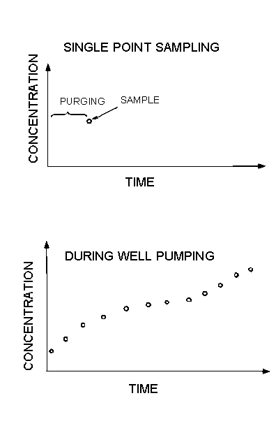
Scan sampling of aquifers is rarely done. The major deterrent is the cost of analyses and the slow turn-around for laboratory analyses. For aquifer scanning to be efficient, rapid accurate analyses are needed in the field at the time of sampling so that sampling frequency and duration of pumping can be adjusted appropriately during the course of the sampling program. T he analyses should have low detection limits because, as distant zones of contamination are drawn to the well, concentrations from the well can be diluted far below their in-situ values. Therefore, potential to use aquifer scanning will be limited until relatively low-cost field analyses with good accuracy and precision become widely available. Automated field-useable analytical equipment for VOC analyses now exists in the prototype stage (e.g. Bianchi-Mosquera et. al., 1991). It is expected that such equipment will soon become commercially available.
Investigation Of Fractured Aquitards
The fractures in aquitards that are generally the most important in groundwater contamination are vertical or near-vertical. The usefulness of vertical boreholes/ vertical monitoring wells is often very limited because of the low probability of detecting the critical fractures. Angle or horizontal boreholes provide much greater probability of obtaining data from critical fractures. In clay or silt aquitards continuous cores from angled holes can be divided into numerous segments for analysis of extracted pore water or solids. The main limitations in this approach are in the drilling. The methods normally available for drilling angle holes in clayey deposits, such as hollow stem augering, provide little control at depth on the angle of the lead augers, and therefore poor information on the subsurface location of the bit. The position of deep cores is poorly known. Technologies solving this problem in the petroleum industry have been little used in hydrogeology. Angled boreholes in clayey aquitards are rare in hydrogeology even though the need is apparent. Technology transfer in this area is lagging. Perhaps this is due to the difficulty of installing monitor wells in angled holes. However in many cases, few wells are needed if sufficient angle cores are taken for analysis of contaminant concentrations in core samples.
Investigations of contaminant migration in vertical or near vertical fractures in fractured-- rock aquitards have much different problems than those in clayey aquitards. Continuous cores of fractured rock usually provide little data on contaminant occurrence on the fracture surfaces. Water or air and water are circulated in the borehole at all times during the coring operation. With available rock coring methods this circulation flushes contaminants from the fracture surfaces. In low matrix-porosity crystalline rock such as granite there is little penetration of contaminants into the rock matrix by molecular diffusion. Therefore, analysis of contaminant concentrations in core samples of low-porosity rock is rarely fruitful. Rocks with larger matrix porosity such as sandstone, siltstone, or shale may have sufficient diffusive penetration of contaminants into the rock matrix for detection in rock slices, thereby providing relevant data from cores even if the fracture faces are flushed free of contaminants during drilling. However, this approach to core use is new to VOC studies and there is a need for establishment of reliable protocols for analysis of core segments or slices.
Multilevel Monitoring In Single Boreholes
To acquire detailed spatial data from fractured rock two approaches are available: first, double-packers, with a sampling port between the packers, inflated temporarily at various levels for sampling and, second, a modular assembly of packers, pipe, and ports for measurement of water pressure and acquisition of water samples. The bulk fracture porosity of nearly all fractured rock except karstic limestone or dolomite is so small, commonly less than 0.1 percent, that the first method produces disturbed chemical data from the fracture network due to purging of the sampling zone before sampling. Purging is necessary because cross circulation from one depth to another in the borehole occurs when the packers are not in the hole, which is most of the time.
Three modular packer-and-port systems for fractured rock are currently used in North America. Early versions of these systems are described by Black et. al., 1986; Welch and Lee 1987, and Dunnicliff (1988). These monitoring systems generally have between five and ten monitoring ports in each borehole; each port is separated from those above and below by two or more packers. The systems are installed permanently or for a long period of time. The systems are improving from year to year, taking advantage of better materials and miniaturized components. Each of these devices provides profiles of hydraulic head and samples for water chemistry. The systems have the exceptional capability to monitor in angled boreholes. They can be easily installed in angled boreholes, which is not the case for conventional wells. By installation of many of these modular systems in vertical and angled holes, exceptionally detailed monitoring can be done. Numerous sampling ports lead to numerous samples for analysis. This results in high analytical costs if the samples are analyzed for long suites of organic compounds, as is the common demand of regulatory agencies in studies of waste or industrial sites.
The modular systems have small ports that yield water for sampling at slow rates. The slow yield is generally advantageous for sampling to avoid excessive disturbance or mixing of the contaminant distribution in the fracture network. The most useful contaminant concentration data are obtained when the ports are sampled several times during slow pumping of each port to obtain concentration versus time relations for the ports. This provides insight on concentration patterns in the fracture network.
The main limiting factor in the use of the modular systems is the cost and turnaround time of analyses. On-site analytical frequently, until the available financial resources are consumed. Typically, this process takes a long time at high cumulative cost.
Recognition of this deficiency has lead to increased use of field equipment at the drill site for measurement or estimation of contaminant concentrations. Often, an appropriate objective is to sample the bottom of the hole at many depths as it is drilled. The samples are analysed immediately so that decisions on additional sampling and maximum depth of the hole can be made during drilling. At present the sampling methods are crude or slow. The analyses are done at surface usually using small portable equipment producing data with accuracy and precision far below laboratory values. The data are not accepted by regulatory agencies, except as information facilitating selection of points for installation of conventional monitoring wells for acquisition of data using established protocols.
A goal of monitoring technology development should be establishment of drilling and sampling techniques and associated field analysis equipment and field protocols for production of contaminant concentration data that have the level of acceptability of samples from conventional monitoring wells with full-protocol laboratory analyses. Until this goal is met, expensive studies at many sites will continue to yield inadequate sets of concentration data from complex hydrogeologic systems. By inadequate I refer tospatial coverage of sampling points inadequate for technical resolution of site problems.
Mackay (1990) points out that it is not infrequent in site studies for careful review of expensive GC/MS analyses to show that much less expensive analytical methods would be capable of detecting all of the contaminants, perhaps even at a lower detection limit. He indicates also that there appears to be good reason to conduct a portion of the analytical work in the field. Protocols for field analyses acceptable to regulatory agencies need to be developed so that low-cost field analyses can supplant many laboratory analyses rather than only augment them.
A conventional monitoring well offers the advantage of access for repetitive sampling. Concentration versus time and water level versus time records can be developed over months or years. This is necessary in some cases but in many studies for risk assessment or remedy selection such records are not needed. Detailed spatial snapshots of hydraulic head and groundwater concentrations can often provide an adequate data base for risk assessment or remedy selection because groundwater flow is typically so slow that spatial distributions change little over months or even years. It can be argued that sampling over months is necessary to establish credible analyses following the formation disturbance caused by drilling. The need, however, is for drilling techniques that minimize formation water disturbance so that immediate sampling has validity.
Technically advanced versions of the piezo-cone and the protocols, has come a large increase in the cost of each chemical data point. A major implication in site investigations of the three factors described above (dispersion, DNAPL, and fractured aquitards) is recognition of the need for much more detailed three-dimensional hydraulic and chemical data. The recent advances in monitoring technologies and protocols have done little to fulfill this need. To meet this need the cost per chemical data point must decline rather than continue to increase.
At some sites the cost of a single nest of monitoring wells (several wells in the nest or an equivalent modular multilevel device in a single borehole) with one full chemical data set from the nest exceeds fifty thousand or even one hundred thousand dollars. This includes the cost of handling and disposing of contaminated borehole cuttings and water. If the site is a DNAPL site or is a site on fractured rock, one nest is usually an insignificant step towards achievement of the level of under- standing necessary for a reliable risk assessment or remedy selection. Many tens of nests per site or many more may be necessary to achieve these practical goals. It is entirely feasible at many sites (such as SUPERFUND or RCRA sites) to spend millions of dollars on a monitoring network without producing the site data necessary for the goals to be accomplished. This is not to say that the achievements in monitoring of the past decade have been ill-advised, rather it is that they have been primarily unidirectional, leaving an urgent need for advances of a much different nature in the 1990s.
SOME DIRECTIONS FOR DEVELOPMENT OF NEW TECHNOLOGY
This consideration of needs in monitoring technology and strategy focuses on three dimensional complexities in groundwater systems caused by weak dispersion, fractures or DNAPL or combinations thereof. The challenge is to develop efficient means for achieving adequate spatial and temporal distributions of data so that the level of understanding of the groundwater system is commensurate with the needs of site risk assessment or remedy selection/design. The practical goal should be to reduce the cost per data point and to increase the probability of acquiring data points from the important or essential locations over the most relevant time scale.
Real Time Field Data Acquisition
In the conventional site investigation the locations and depths of wells are specified before arrival of the drill rig on site. The monitor wells are installed. The drill rig then leaves the site and later on the wells are sampled. After considerable delay the analytical results are received from the laboratory and data interpretation commences. It is often found that the monitor network answers some questions at this stage and raises many new ones. At this point another phase of drilling and well installing begins and the site investigation proceeds from phase to phase until the necessary detail of site data is acquired or, more systems that do laboratory-grade analyses with fast turn-around are needed to bring modular monitoring systems into the mainstream of groundwater contamination studies. Until this happens investigations of contaminant occurrence and migration in fractured rock at many sites will remain hampered by inadequate spatial distribution of data points.
The modular systems described above can only be installed in boreholes open from top to bottom at the time the system is lowered down the borehole. Therefore, these systems, like conventional wells, do not circumvent the propensity for DNAPL to run down the borehole if the hole penetrates a zone of free liquid- phase DNAPL.
SUMMARY OF CONCLUSIONS
The major advances in groundwater monitoring at waste disposal and industrial sites made during the past decade pertain primarily to the design, construction and installation of conventional monitoring wells and to the equipment and protocols for sampling these wells. Also, advanced protocols used for routine laboratory analyses, particularly for organic chemicals, have achieved common use. The importance of these advances notwithstanding, little progress has been made in the development of cost-effective technologies for detailed determination of the spatial distribution of contamination in most types of hydrogeologic systems. This deficiency severely impedes progress towards reliable risk assessments of groundwater contamination, selection of site remedies, and monitoring of progress of remedial action. Recent studies of dispersion in sand and gravel aquifers show week transverse dispersion. This magnifies the difficulty of achieving adequate understanding of the spatial distribution of contaminants using conventional wells.
To decrease the cost of chemical analyses in site investigations and to provide greater insight on the location and internal character of contaminant plumes, there is an urgent need for new technologies for reliable and accurate on-site chemical analyses, preferably technologies with a high degree of automation and ease-of-use. These technologies should fulfill many needs such as rapid turn-around time so that field decisions can be made during drilling, development of concentration-versus-time relations for monitor wells and modular multilevel systems, automated analyses for pumping tests and pump-and-treat remediation, and scanning of aquifers for contamination.
Many waste or industrial sites within SUPERFUND and RCRA and other sites such as those on military land have DNAPL in the groundwater zone. The monitoring methods used in DNAPL areas are generally poorly suited for these areas because they typically produce results unrepresentative of the actual site conditions, or worse, cause contamination to spread to greater depth due to drilling effects. The importance of DNAPL in site investigations has only come to light since the mid-1980s and the development of monitoring methods specific to DNAPL problems is in its infancy.
REFERENCES
Bianchi-Mosquera, G.C., D.M. Mackay, G.D. Hopkins, 1991, Monitoring of organic tracer tests: Recent methods and results. National Research and Development Conference on the Control of Hazardous Materials, Feb. 20-22,1991, Anaheim, Calif., Proceedings, 502-505.
Black, W.H., H.R. Smith and F.D. Patton, 1986, Multiple-level groundwater monitoring with the MP System, NWWA-AGU Conference On Surface And Borehole Geophysical Methods And Groundwater Instrumentation. Denver, Colorado, October 15-17, Proceedings, 41-61.
Cherry, J. A., 1983, Occurrence and migration of contaminants in groundwater at municipal landfills on sand aquifers. In: Environment and Solid Wastes, Editors, C.W. Francis, S.I. Auerbach and V.A. Jacobs, Butterworths, Boston,l24-l47.
Dunnicliff, John, 1988, Geotechnical instrumentation for monitoring field performance, Wiley-Interscience, New York, 136-139.
Freyberg, D.L., 1986, A natural gradient experiment on solute transport in a sand aquifer, 2, Spatial moments and the advection and dispersion of nonreactive tracers, Water Resources Research, Vol.22, no. 13, 2031-2046.
Grabedian, S.P.,D.R. LeBlanc, L.W. Gelhar, and M.A. Celia, Large-scale natural gradient tracer test in sand and gravel, Cape Cod, Massachusetts, 2, Analysis of spatial moments of a nonreactive tracer, Water Resources Research, Vol.27, no. 5, 911-924.
Harrison B., E.A. Sudicky, and J.A. Cherry, Numerical analysis of solute migration through fractured clayey deposits into underlying aquifers, Water Resources Research, submitted, April 1991.
Huling S.G., and J.W. Weaver, 1991, Dense Nonaqueous Phase Liquids, U.S. Environmental Protection Agency, EPA/540/4-91-002, 2lpp.
Kueper, B.H. and D.B. McWhorter, The behavior of dense non-aqueous phase liquids in fractured clay and rock, Ground Water (in press)
LeBlanc D.R., 1984, Sewage plume in a sand and gravel aquifer, Cape Cod, Massachusetts, U.S. Geological Survey Water-Supply Paper 2218, 28p.
LeBlanc D.R., S.P. Garabedian, K.M. Hess, L.W. Gelhar, R.D. Quadri,K.G. Stollerwerk,and W.W. Wood, 1991, Large-scale natural gradient tracer test in sand and gravel, Cape Cod, Massachusetts, 1.Experimental design and observed tracer movement, Water Resources Research, Vol.27, No.5 895-910.
Lehr J.H., 1988, An irreverent view of contaminant dispersion. Groundwater Monitoring Review, Vol. 8, no. 4, 4-6.
Luba, L.D., 1991, An analysis of a long thin chloride plume in a sandy aquifer, Master Of Science Project, Department of Earth
Sciences, Waterloo, Ontario, 89 pp.MacFarlane D.S. J.A.Cherry, R.W. Gillham and E.A. Sudicky,1983, Migration of contaminants in groundwater at a landfill: A case study, 1. Groundwater flow and plume delineation. Journal of Hydrology, Vol.63, 1-29.
Mackay D.M. 1990, Characterization of the distribution and behavior of contaminants in the subsurface. In, Ground Water and Soil Contamination Remediation: Toward Compatible Science, Policy, and Public Perception, Colloquium 5 Of A Series, National Academy Press, Washington, D.C., 70-90.
Mackay D.M. and J.A. Cherry, 1989, Groundwater contamination:Limitations of pump-and-treat remediation. Environmental Science and Technology, Vol.23, No. 6, 630-636.
Moltyaner, G.L. and R.W.D. Killey, 1988 Twin Lake Tracer Test:transverse dispersion, Water Resources Research, Vol. 24, No. 1,1628-1637.
Robertson W.D., J.A. Cherry, and E.A. Sudicky, 1991, Ground-water contamination from two small septic systems on sand aquifers, Ground-Water, Vol.29, No. 1, 82-92.
Robertson W.D. and J.A. Cherry, Hydrogeology of an unconfined sand aquifer and its effect on the behavior of nitrogen from a large-flux septic system, International Journal of Applied Hydrogeology (in press).
Sudicky, E.A. J.A. Cherry, and E.O. Frind, 1983, Migration of contaminants in groundwater at a landfill: a case study. 4, A natural gradient tracer test. Journal of Hydrology, Vol. 63, 81-108.
Sudicky, E.A. and R.G. McLaren, The Laplace Transform Galerkin Technique for large-scale simulation of mass transport in discetely-fractured porous media, Water Resources Research, in press.
Schwille, F., 1988, Dense chlorinated solvents in porous and fractured media-model experiments. Translated by J.F. Pankow, Lewis Publishers, Chelsea, Michigan.
Welch S.J. and D.R. Lee, 1987, A multiple packer/standpipe system for ground water monitoring in consolidated media, Ground Water Monitoring Review, Summer.

References as:""Cherry, J.A., 'Groundwater Monitoring: Some Deficiencies and Opportunities,' Hazardous Waste Site Investigations; Towards Better Decisions, Lewis Publishers, B.A. Berven & R.B. Gammage, Editors. Proceedings of the 10th ORNL Life Sciences Symposium, Gatlinburg, Tennessee, May 21--24, 1990."
|
|